


Tulkarm (Tulkarem), Palestine: History, the Kadoorie School and Its Farmland
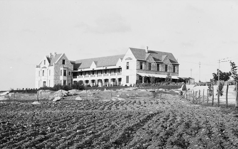
The people of Tulkarm gave away 600 dunums of their own farmland so that a school could be built to teach farming on it. That is the shape of the whole town in one decision. Tulkarm, Palestine sits on the first hill a traveller meets coming inland from the Mediterranean, and its Arabic name, Ṭūlkarm (طولكرم), carries a vineyard inside it. Its people call themselves Karmis. Land was never a backdrop here; it was the profession, the address and the surname, which is also why the plain, hard-wearing dress of its women looks so different from the dense embroidery that Palestinian heritage clothing is usually pictured in.
TL;DR
Tulkarm, also written Tulkarem, is a Palestinian city in the north-western West Bank, about 15 kilometres east of the Mediterranean coast and 23 kilometres west of Nablus. Its name descends from the Aramaic Ṭur Karma, mount of the vineyard. Kurdish military settlers of the Zaydan family were placed on its pass after 1187, and the whole village was later held as waqf for a religious school in Jerusalem. It became a subdistrict centre in 1876, a municipality in 1892 and a rail junction in 1908. In 1930 the Kadoorie Agricultural School was founded on 600 dunums the townspeople donated. In 1945 Tulkarm counted 8,090 people and 32,610 dunums of rural land. The 1949 armistice line left roughly 30,000 of those dunums on the Israeli side.
What Does the Name Tulkarm Mean?
The Arabic reads as a length of vineyard, and the older form behind it is the Aramaic Ṭur Karma, mount of the vineyard, a name the Crusaders and the medieval Samaritan inhabitants both used for the place. Pierre Jacotin's surveyors, mapping the country during the French invasion of 1799, wrote it down as Toun Karin.
The name is doing geography. The town stands on a hill of about 125 metres where the foothills of Jabal Nablus meet the coastal plain, with an unobstructed view west to the sea. That single hill decided everything that followed: it was defensible, it commanded the road inland, and it sat above ground good enough to farm.
It also decided where people slept. The plain was more fertile than the hill, but its winter marshes bred malarial mosquitoes, so families who owned land in both places built their houses high and walked down to sow and reap, camping in huts and tents through the spring. The town on the hill was the safe address; the wealth was in the fields below it.
The Vineyard Hill Under the Ayyubids, Mamluks and Ottomans
The historian Farid al-Salim, whose study of the town's land records is cited below, traces the first Muslim settlers to a Kurdish group that arrived in central Palestine in the era of Saladin, after 1187. Among them was the Zaydan family, military settlers placed in the pass to hold the western approach, and by his account they dominated the town until the early 1600s. These are a separate line from the better-known Zaydans of the Galilee. A group of Arab peasant farmers and herders followed from southern Palestine around 1230, and a third wave came in the fourteenth century from North Africa and from nearby Nablus, supplying hides to the tanneries of the coastal towns.
What made Tulkarm unusual was its ownership. The village was designated waqf, an endowment supporting the al-Jawhariyya Madrasa in Jerusalem, and the local religious families administered that trust themselves. As al-Salim sets out in his study of landed property in Ottoman Tulkarm, published in the Jerusalem Quarterly, this put taxation and administration in the hands of resident families for centuries rather than rotating outsiders, and it is the reason its records read as a story about land tenure more than about rulers.
Ottoman rule arrived in 1517, and Sultan Suleiman transferred the town's waqf during his reign between 1520 and 1566. The tax registers of 1596 list 176 Muslim households. When Conder and Kitchener's Survey of Western Palestine reached the site in 1882, they recorded a long straggling village on high ground, ringed by arable land and rock, with a number of good-sized stone houses.
A Junction, Not a Backwater

Administratively it rose quickly, becoming the centre of a new subdistrict, Bani Saʿb-Tulkarm, in 1876, and a municipality in 1892, which gave it precedence over the surrounding villages, Qalqilya among them. A governor was appointed to a place of only a few thousand people, most of them fellahin.
Then came the track. In 1908 Tulkarm became a rail junction on the network running up from Egypt and southern Palestine toward Haifa on the northern coast and eastward to the Hejaz line. The Ottoman army used the town as one of its principal bases in the Sinai and Palestine campaign, it was bombed from the air, and British forces took it in 1918. A road to Netanya on the coast was built in 1920. By the Mandate's later years the survey sheets show a dual gauge line, a landing ground, government and police offices, and an agricultural school, which is a great deal of infrastructure for a town of eight thousand.
Six Hundred Dunums for a School
The Kadoorie Agricultural School is the part of the town's record that deserves to be better known. The land came from the town. As the successor institution records in its own account of its founding, the people of Tulkarm donated 600 dunums for an agricultural school, and the building was funded by the philanthropist Ellis Kadoorie, with the school established in 1930.
Teaching began in 1931 with 60 students on a three-year diploma. Between 1936 and 1939 the British military took the school over, and a large part of its farmland stayed under Mandate control until 1946. It became Hussein Agricultural College under Jordanian administration in 1961, and on 28 August 2007 it was granted full university status as Palestine Technical University, Kadoorie.
A town that lived off its fields put up the land to teach the science of fields. That is a specific kind of confidence, and it belongs in the record next to the more familiar Palestinian crafts.
Lesser-Known Facts About Tulkarm
- People from Tulkarm call themselves Karmis, after the vineyard in the town's name.
- The town receives more than 550 millimetres of rain a year, which is high for Palestine and is why the surrounding plain grew cereals rather than needing irrigation.
- Houses were built in hosh compounds of ten to twenty rooms around a shared central circle, each holding six to ten families of one hamula.
- The British Mandate census recorded 3,350 people in 1922 and 4,827 in 1931, of whom 4,540 were Muslims; the 2017 Palestinian census counted 64,532.
- Of the 32,610 rural dunums recorded in 1945, 28,256 were under cereals and 2,399 under citrus and bananas.
- UNRWA records that Nur Shams camp exists because a snowstorm destroyed the tents of refugees sheltering in the Jenin area and forced them to relocate to Tulkarm.
What Happened to Tulkarm's Farmland in 1949?
In the 1945 village statistics the town had 8,090 residents, of whom 7,790 were Muslim and 280 Christian, with 1,672 dunums of urban land and 32,610 dunams of rural land around it. Almost all of that rural land was in crops.
During the war of 1948 the town was held by the Iraqi army and afterwards annexed with the rest of the West Bank to Jordan. The armistice agreements of 1949 then drew a line that left roughly 30,000 of Tulkarm's 32,610 dunums, overwhelmingly agricultural, on the Israeli side of it. The town kept its houses and lost its fields.
The consequences followed immediately. Residents left for Transjordan or went abroad looking for work. Sitting directly on the line, Tulkarm was cut off from the Arab towns of the coastal plain it had always traded with, and Nablus, some twenty kilometres east through the hills, became its main economic and social connection by default.
Refugees arrived at the same moment the land went. UNRWA established Tulkarm camp in 1950 on 0.18 square kilometres, for families displaced from Jaffa, Caesarea and Haifa. Nur Shams camp followed in 1952 on 0.21 square kilometres, three kilometres east. By 2023 the two camps carried 27,631 and 13,739 registered refugees on that ground, a density in Nur Shams of roughly 65,000 people per square kilometre.
Plain Gowns and the Map on the Chest

The dress record of Tulkarm is thin, and the reason is the fields. The traditional costume of women here was a plain, dark-coloured gown, worn with or without embroidery, in the manner of the rural north rather than the heavily stitched south. Where a Bethlehem or a Beersheba panel would be crowded, a Tulkarm chest panel tends to be sparse, with the stitching held to the qabbeh and sometimes the ankles of the trousers worn beneath, and a great deal of undecorated cloth left alone.
This is worth saying plainly, because heritage writing has a habit of flattening every Palestinian district into the same dense cross stitch. It was not the same everywhere. Its women were working the cereal land that made the town rich, and their dress reflects a working economy, not a poorer one. Village particularism was still there; al-Salim notes that it came out in embroidery and dress styles alongside dialect, songs, food and wedding custom. There was simply less thread in it.
Then the land went, and the thread came back. Field surveys of the city now describe embroidery as the main source of income for its women, and the image they stitch most often is the map of historic Palestine. A district that once had too much farming to embroider densely now earns its living from the needle, and what it puts on the cloth is the ground it lost. Set that beside the stitched village grammar of tatreez and the point sharpens: the thobe and its chest panel have never been decoration. They record what a place has and what it has been made to give up.
Frequently Asked Questions
Where is Tulkarm in Palestine?
Tulkarm is in the north-western West Bank, on the western edge of the northern hill country. It lies about 23 kilometres west of Nablus and about 15 kilometres east of the Mediterranean coast at Netanya, on the first hill that rises from the coastal plain, at an elevation of roughly 125 metres.
What does the name Tulkarm mean?
In Arabic the name reads as a length of vineyard. It descends from the Aramaic Ṭur Karma, meaning mount of the vineyard, which was the form used by the Crusaders and by the medieval Samaritan inhabitants. People from the town call themselves Karmis after it.
What is the Kadoorie school in Tulkarm?
The Kadoorie Agricultural School was founded at Tulkarm in 1930 on 600 dunums donated by the townspeople, with funding from the philanthropist Ellis Kadoorie. Teaching began in 1931 with 60 students. It became Hussein Agricultural College in 1961 and was granted university status in 2007 as Palestine Technical University, Kadoorie.
How much of Tulkarm's land was lost in 1949?
The 1949 armistice agreements between Israel and Jordan left roughly 30,000 of the town's 32,610 rural dunums, most of it agricultural, on the Israeli side of the line. Tulkarm retained its built-up area and lost the great majority of the fields that had supported it.
What is Tulkarm known for?
Historically, for farming. It was the centre of a subdistrict of cereal and citrus land, a rail junction from 1908, and the site of the Kadoorie Agricultural School, founded in 1930 on land the townspeople donated. Today it is known for the Kadoorie university that grew out of that school, and for embroidery, which has become the main source of income for many of the city's women.
A Town That Gave Its Land to a School and Then Lost the Rest
Most Palestinian city profiles are built around what a place made: soap in Nablus, glass in Hebron, oranges shipped out of Jaffa. Tulkarm made grain, and grain leaves no artefact. What it left instead is a paper trail about land: a village held as an endowment for a Jerusalem school, a survey line through 32,610 dunums, a deed for 600 of them signed over to a college, and two camps measured in fractions of a square kilometre.
That is why the embroidery matters here more than it would elsewhere. In a district that historically stitched sparingly, the needle became the work only after the fields were gone, and the motif that took hold was the outline of the country itself. The women of Tulkarm are not decorating cloth. They are keeping a record in the one medium that could not be redrawn by an armistice line.

Written for FALASTIN by Jad Sahyoun, with the assistance of AI tools and checked against Ottoman-period scholarship, Mandate land statistics, United Nations records and the founding account published by Palestine Technical University, Kadoorie.
At FALASTIN, we aim to keep that heritage alive through our Heritage Olive Tree collection.
100% of profits from FALASTIN are donated to the United Palestinian Appeal.